|
|||||||||||||||
|
| |||||||||||||||
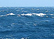
Storms pass north of the Central Coast 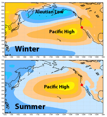 This illustration shows how the Pacific High expands and the Aleutian Low contracts between winter (top) and summer (bottom). Storms tend to travel along the northern edge of the Pacific High. The red dot indicates the location of the Central California Coast. (Source: NOAA/NCDC) By May, the water of the Pacific Ocean between California and Hawaii has become relatively warm (over 60 degrees F). This allows a large "bubble" of warm air over the ocean (the Pacific High), to expand northward and become stronger. By May, the Pacific High is growing in strength, and deflects most storms moving from the Gulf of Alaska so that they move eastward toward Oregon or Washington. Protected by the Pacific High, the Central Coast rarely sees rain after mid May. However, the weakened remnants of some low pressure systems may occasionally bring fog or drizzle to the area. Other low pressure systems pass just north of the Central Coast, bringing strong northwest winds to the area. Note: The Pacific High is not just a summer phenomenon. It often forms during the winter months, but is centered fairly far south, and is relatively weak. A southerly flowing jet stream and strong winter storms may disrupt or dissipate the Pacific High for weeks at a time. Northwest winds peak The northwest winds and upwelling that begin in March and ramp up in April become most consistent in May. By late April or early May, strong northwest winds and upwelling may become nearly continuous over the coastal waters within 10 to 20 miles of the coast. Note: April may see even stronger northwest winds than May. However, the northwest winds are less consistent in April, because they alternate with southeast winds from storms that manage to push aside the Pacific High and reach the Central Coast. Upwelling peaks May often sees northwest winds howling for days on end, bringing huge volumes cold water up toward the sea surface. This upwelling of cold water is strongest where points of land jut out from the coast, such as at Point Arena, Point Reyes, Año Nuevo, and Point Sur. From these "upwelling centers" the cold water flows far out to sea, as well as southward along the coast. 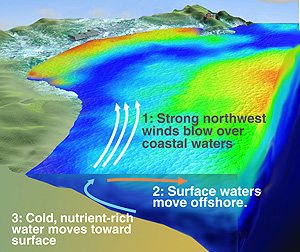 This illustration shows a plume of cold water (blue) known as the Davenport Upwelling Plume, which moves southward along the coast from the upwelling center at Point Año Nuevo, and across Monterey Bay (Source: David Fierstein/MBARI) Just south of Point Año Nuevo, for example, the Davenport Upwelling Plume reaches maximum velocity and strength in May. After forming near Point Año Nuevo, this river of cold water flows along the coast northwest of Santa Cruz, then streams out across the mouth of Monterey Bay. Sometimes the Davenport plume hits the Monterey Peninsula. Other times it flows farther offshore and continues down along the Big Sur coast. By mid May, upwelling plumes have affected most of the Central California coast, bringing the coldest water of the year to the waters of the outer continental shelf (10 to 20 miles offshore). The exceptions are "upwelling-shadow" areas in a few sheltered coastal areas. The marine layer strengthens, bringing summer fog By early May, the Pacific High is deflecting most storms northward, away from the Central Coast. Thus, rain is unlikely. At the same time, the atmosphere over the ocean is still somewhat unstable and well mixed, while inland areas are still relatively cool. This reduces the chances that fog will form at the coast. Far out at sea, the Pacific High has become so strong that it doesn't move much. This allows a stable layer of cool, moist air to form just above the ocean surface. This layer is typically 500 to 1,000 feet thick and may blanket hundreds miles of open ocean. Along upper edge of this "marine layer", the cool, moist ocean air comes in contact with much warmer air higher in the atmosphere. This causes water vapor (water in gas form) in the marine layer to condense into tiny droplets of water, similar to the condensation that form on the outside of a glass of cold water. In this case, the drops of condensation are so tiny that they float around, forming mist or high clouds. Note: If you've ever flown or sailed across the Pacific in summer, you may have noticed a nearly continuous cloud cover over the ocean between California and Hawaii. This is the top of the marine layer, which is trapped beneath the Pacific High. This continuous cloud cover not only makes it tough to do celestial navigation. It also hides the jet contrails that some sailors tried used for navigation when sailing from California to Hawaii in the days before satellite navigation and GPS. As May progresses, the Pacific High expands, and the air over the coastal waters becomes more stable. This allows the marine layer to move toward shore, forming a layer from 200 to 2,000 feet thick over the coastal waters. When moisture in the marine layer condenses near the top of this marine layer, it forms the "high clouds" that are the bane of summer visitors to the Central Coast. Note:The "May dismay" and "June gloom" of the Central California coast are not typically caused by fog, which forms at ground level, but by "high clouds." Occasionally, if the marine layer contains enough moisture, water will condense throughout the entire layer, and thus reach the ground, forming true "fog." This is particularly common along the parts of the coast facing the west and northwest. 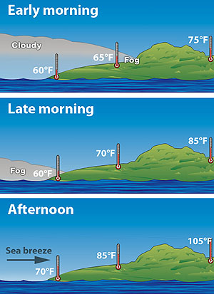 The daily shift from fog in marine layer to afternoon sea breeze. (Modified from NOAA/NCDC) Because the marine layer is usually less than a thousand feet thick, it is typically blocked by coastal mountains. But if the marine layer is thick enough, it can flow inland through gaps in the coastal mountain ranges, and occasionally over the tops of them. The net result is that, as May turns into June, the coast gets lots of fog, but areas just inland from the coast receive more and more sunshine. As the land warms up each day, so does the air above it. At the same time, heat from the morning sun causes the condensed water droplets at the top and inland edges of the marine layer to evaporate. This process helps clear the clouds that formed or moved inland during the night. However, especially in late May and June, such clearing may not extend to coastal areas. By afternoon, sunny mountain slopes and inland areas have heated up, and have transferred that heat to air above them, which begins to rise (just like a hot-air balloon). As the warm air rises, cooler ocean air rushes in to take its place. This can have two possible effects. If the clouds in the marine layer have completely evaporated, the flow of ocean air creates strong onshore winds along the coast. Such afternoon seabreezes can reach 25 to 30 miles and hour, and give a daily boost to the upwelling process. On the other hand, if the rising hot air draws inland marine air still contains a lot of condensed mist, the coastal "fog" may actually be carried inland. 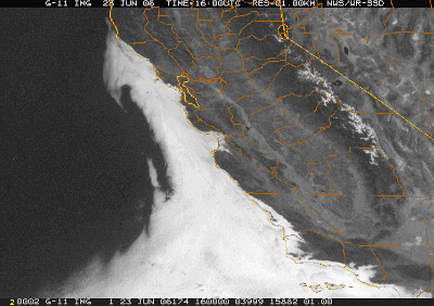 This satellite image shows a "southern surge" of fog that started around Point Conception, moved up the Cental California coast to fill Monterey Bay, and is just getting getting past Point Arena. (Satellite image courtesy of US National Weather Service) Starting in May and continuing through July or August, the Central Coast of California is subjected to a constantly shifting battle between foggy, moist marine air and clear, dry inland air. The net result is that periods of clear, sunny, windy days alternate with cloudy days and light winds. The way this usually plays out is that coastal areas will experience two or three days of warm, sunny weather and gusty afternoon northwest winds, followed by a "surge" of very moist marine air from the southwest. Such "southern surges" of moist marine air and low clouds are easy to see in satellite images as they make their way up the California coast from the south. 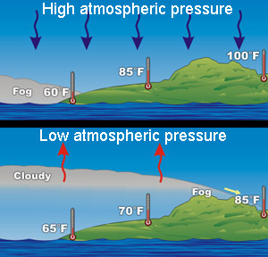 This illustration shows how low pressure systems can lead to a deeper, more persistent marine layer. (Modified from NOAA/NCDC) Similarly, the marine layer sometimes becomes thicker and more moist when a late low-pressure system slides around the northern edge of the Pacific High and reaches the Central Coast. In winter such systems often bring rain, but by May they don't carry enough moisture to make rain. But they do lower the atmospheric pressure, which allows the marine layer to expand vertically and carry much more moisture (see illustration). During late May or June, marine air often wins the atmospheric battle, and foggy mornings become the rule rather than the exception. During the period of "June gloom," overcast mornings may or may not give way to clearing skies in the afternoon. Once an area becomes covered by a fully saturated marine layer, the winds usually become light or blow from the southwest. At the same time, upwelling ceases, and surface waters move toward shore in what oceanographers call a "relaxation event" (the opposite of an upwelling event).
|