|
|||||||||||||||
|
| |||||||||||||||
The gifts of spring: sunlight and nutrients In March, a number of factors combine to dramatically increase the amount of sunlight and essential plant nutrients in the surface waters of the Central Coast. For one thing, the days are becoming longer. In fact, the number of hours of sunlight per day increases more rapidly in March than at any other time of year. Furthermore, the sun rises higher in the sky each day, so more of its light penetrates through the sea surface. March is also when winter storms become less frequent, and bright, sunny days become more common on the Central Coast. When late storms do arrive, they tend to be showery, forming clouds mostly over the coastal mountains, while (in a reversal of the summer fog pattern) beaches and nearshore waters get plenty of sunlight. Even if they don't bring much rain, these late storms stir up the atmosphere, making it less likely that fog will form along the coast. All of these factors combine to bring an increase in sunshine to human residents of the Central Coast as well as to algae in the coastal waters. The ocean calms and becomes more stratified All this glorious spring sunlight doesn't help microscopic algae very much if the ocean is so churned up that they can’t stay up in the sunlit surface waters. Throughout the winter months, southeasterly storm winds churn up the ocean, so that there is no distinct break in temperature between the surface and the deep waters (see Winds, Waves, and Currents in January/February for details). 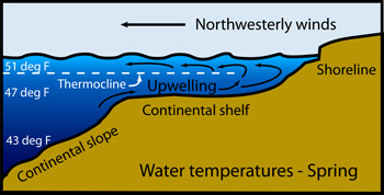 Cross section of the coastal waters during spring. Northwest winds have caused upwelling, bringing cold water up onto the continental shelf. Even though surface waters are colder than in winter, there is often a distinct break in temperature (a thermocline) 100 to 200 feet below the surface. Note: the vertical exaggeration in this diagram is about 100 times (the real ocean is very thin compared to its depth). (Source: Kim Fulton-Bennett) However, once the winter storms die down, a distinct layer of warmer water tends to form near the sea surface. Like the oil floating in an oil-and-vinegar salad dressing, the surface layer is typically between 100 and 200 feet thick. Below this surface layer, and extending down to the deep seafloor, is a layer of much colder (40 to 50 degrees F) and somewhat saltier water. Like oil and vinegar, these two layers don't mix very well, and are separated by a distinct boundary known as the “thermocline.” As spring sunlight warms the surface water, it becomes less dense than the colder water underneath it and the boundary between the two layers becomes more distinct. Once a distinct thermocline forms, water and algae above the thermocline may be carried up and down within the surface layer, but are rarely carried down below the thermocline. Suspended within this stable surface layer, the algae get enough sunlight to grow and reproduce. Most of the algae that bloom along the Central Coast in spring are in a group called diatoms. And many types of diatoms won't grow well (or "bloom") unless they are trapped near the surface by a shallow thermocline. In addition to helping keep diatoms near the surface, the shallow thermocline has a second, and perhaps even more important, effect—it facilitates the process known as upwelling, which is described in greater detail below. Northwest winds cause upwelling events Once a shallow thermocline forms, the stage is set for the beginning of spring upwelling. Upwelling occurs when winds from the northwest push surface water away from the shore, allowing cold water to rise up from below to take its place. In general, the shallower the layer of surface water, the easier it is for the wind to push this layer away from shore. Especially in early spring, upwelling usually takes place during periodic events, which typically last from two to five days. All that is needed to begin an upwelling event is a day or two of northwest winds blowing at 20 knots or more over the coastal waters. You can read a detailed description of a typical upwelling event elsewhere on this site. 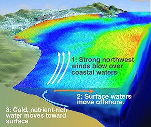 This diagram shows how cold, upwelled water (blue) flows from Point Año Nuevo down the coast and across the surface of Monterey Bay. Warmer water (orange and red) lies offshore and in the northeast corner of the bay. Note: the vertical exaggeration in this diagram is about 100 times (the real ocean is very thin compared to its depth). (Source: David Fierstein / MBARI) Although northwest winds blow more or less parallel to the shoreline, because of the Coriolis effect, their net effect is to push surface water away from the coast. As the surface water moves offshore, cold, nutrient-rich water rises up from depths of 300 feet or more (below the thermocline) to take its place. As this deep water rises, it draws even colder bottom water in toward the coast. This process continues as long as the northwest wind blows strongly across the ocean surface. On the Central California coast, occasional upwelling events may occur at any time of year. However, they are relatively rare in winter. Starting in March (and following the formation of a shallow thermocline), upwelling events become more and more frequent. Note: By the peak of the "upwelling season" in May, northwest winds may continue for weeks at a time, and upwelling may be almost continuous. The "upwelling season" typically ends in June or July, when the northwest winds weaken and upwelling events become more sporadic again. The spring "upwelling season" typically begins in March because this is when winter storm winds from the southeast begin to alternate with strong winds from the northwest. This change in wind patterns reflects the fact that spring storms often follow a more northerly path across the Pacific Ocean than do typical winter storms. Instead of approaching the Central Coast from the west-northwest, spring storms are more likely to head across the Gulf of Alaska toward the coast of Oregon or Washington, then dive southward. Such storms approach the Central California coast from the north or northwest and move rapidly through the area. They may bring short periods of southeast winds, but these are often followed by several days of strong winds from the northwest. It is these northwest winds trigger the first spring upwelling events. Upwelling events carry nutrients up toward the sea surface Each upwelling event injects a pulse of nutrients into the sunlit surface water. These nutrients allow marine algae (including diatoms, kelp, and seaweeds) to begin their annual growth spurt in February or March. Algae require many of the same nutrients as do land plants. If you read the list of nutrients on a bag of garden fertilizer, you will see that the main ingredients are phosphorus and nitrogen. There is usually plenty of phosphorus in Central Coast waters. However, nitrogen is often in short supply, particularly the dissolved form of nitrogen--nitrate--that is preferred by spring-bloom diatoms. In addition to nitrogen and phosphorus, diatoms need minerals such as silica to build their tiny, jewel-like shells. They also need trace metals such as iron, which is essential for photosynthesis. The deep water that rises up toward the surface during spring upwelling events is rich in nitrate, phosphate, silica, and iron, and thus makes a perfect fertilizer for diatoms. "Upwelling-shadow" areas retain warmer, more stable water Some coastal areas that are sheltered from northwest winds and upwelling currents are much less effected by upwelling. These areas, known as "upwelling shadows" are typically in the lees of headlands or bays. Some notable upwelling-shadow areas include the northeast corner of Monterey Bay (roughly Pleasure Point to Seacliff Beach), Bolinas Bay, and Bodega Bay. Smaller upwelling shadows may exist behind smaller headlands such as Pillar Point and Point Sur. Many upwelling shadows contain circular eddies that trap water close to shore, leading to what oceanographers call a long "retention time." This means that the water in upwelling shadows does not mix very much with water from outside the upwelling shadow, at least while upwelling is active. The water in upwelling shadow areas is typically warmer because cold upwelled water does not commonly reach these areas. Because of its long retention time, the water (at least near the surface) also has time to be warmed by the sun. Thus upwelling-shadow areas offer some of the warmest water for human beach-goers (even if it's still not very warm compared to the water off Southern California). Upwelling-shadow areas may also contain very different communities of microscopic drifting algae and animals than other coastal areas. The warm, stable water in these areas favors the growth of certain types of algae, such as dinoflagellates. Since some dinoflagellates cause red tides, upwelling-shadow areas sometimes serve as "red-tide incubators." Because of all these algae, the water in upwelling-shadow areas is often murky and green or brown (depending on the types of microscopic algae present). All of these growing algae eventually use up the nutrients that the algae need to grow. Thus the algae in these areas may be abundant, but not necessarily very healthy. They periodically get a shot of new nutrients when the currents change, allowing colder, more nutrient-rich water to mix with the warm, low-nutrient water in the upwelling shadow. Eddying currents within upwelling-shadow areas also keep tiny, drifting larvae and other microscopic animals close to shore. The warm water also allows them to grow relatively quickly, if they can get enough food (algae) to eat. Larger animals, such as leopard sharks, also use protected coves in upwelling-shadow areas as nurseries. |