|
|||||||||||||||
|
| |||||||||||||||
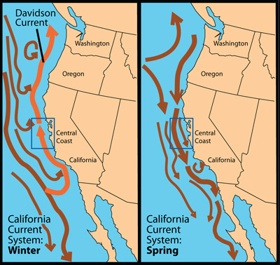
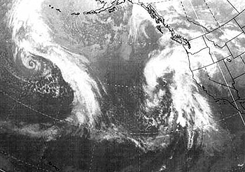
The season of storms Both on the land and in the sea, January is the fiercest month of the year. Powerful winter storms sweep across the North Pacific, one after another, each storm bringing several days of rain and strong southeast winds to the Central Coast. Between storms, the winds are either calm or blow lightly from the southwest, east, or southeast. The sky often remains overcast--a harbinger of the next incoming storm. Each winter storm follows a different path across the Pacific Ocean, steered by the jet stream--a band of strong, high-altitude winds that flows like a meandering river of air around the entire Northern Hemisphere. When the jet stream meanders northward, winter storms travel along an easterly or southeasterly track across the Gulf of the Alaska. After hitting Seattle or Vancouver, some storms head south and swoop down toward the Central California coast. These storms bring waves of cold Aleutian air to our region. They may also bring strong ocean swells from the northwest. Every so often (more often during El Niño years), the jet stream meanders toward the south, allowing storms to approach the Central Coast from the west or southwest. These “pineapple express" storms carry moist, semi-tropical air to the Central Coast, sometimes generating heavy rains. When several “pineapple express” storms follow one another across the Pacific, their combined winds may generate some of the largest swells to reach the Central Coast. These swells approach the coast from the west or southwest, and thus can reach parts of the coast that are sheltered from the more typical northwest swells. Because they have traveled so far (several thousand miles), the time between waves (the wave "period") may be up to 20 seconds, which means that these waves carry a lot of energy for their size. When long-period swells from the west or southwest combine with chaotic southerly wind waves and high tides, serious coastal damage or flooding may occur. Such damage usually takes place within a few hours of high tide, when the high tide is more than 5.5 feet above mean sea level. In addition, low pressure from severe storms can also create a "storm surge" that raises sea level by as much as a foot. Despite the frequent storms of January and February, there are usually a few days when the storm track temporarily shifts northward and high pressure builds over the Central Coast. On those glorious days, the Central Coast basks in clear, sunny weather, with almost calm conditions or winds from the north or northeast. These rare sunny winter days may be more pleasant than the days of summer because there is no chilly afternoon sea breeze. Runoff connects land and sea  Large plumes of sediment from runoff are clearly visible in this satellite image of the coast from San Francisco to Monterey Bay. (Source: NASA) Just as January brings some of the strongest winds and largest waves to the Central Coast, it is typically the rainiest month of the year. With each rain storm, torrents of muddy water flow down rivers, streams, and storm drains. Following strong or sustained downpours, this runoff creates large plumes of fresh water that flow out over the surface of the ocean. The runoff also carries driftwood, trash, fertilizer, oil, and other chemicals from human activities into the nearshore waters. By far the largest sources of freshwater runoff on the Central Coast are the Sacramento and San Joaquin Rivers, which flow through San Francisco Bay and then out of the Golden Gate. Other sizeable rivers, such as the Salinas, Pajaro, and San Lorenzo Rivers, bring freshwater into Monterey Bay. Because it is less dense than seawater, this freshwater runoff typically remains near the surface of the ocean, where it forms a layer of less-salty water that can be up to 10 or 20 feet thick. Such runoff plumes can travel dozens of miles out to sea. For example, rain storms in the Santa Cruz Mountains often generate low-salinity plumes that can be detected 25 miles from the nearest land. Similarly, runoff flowing out of the Golden Gate sometimes spreads out across the entire Gulf of the Farallones, and may travel down the coast as far as Monterey Bay. Over the course of a typical winter, repeated runoff events can cause a gradual decline in the salinity of surface waters. For example, within Monterey Bay, the average salinity of the surface waters gradually decreases from November through January, and reaches minimum levels in late February or early March. Southeast winds churn the ocean As any fisherman will tell you, winter storms churn up the coastal waters and make it hard to catch fish. In addition to making fish less likely to bite, winter storms change both chemistry and the internal layering of the coastal ocean. This affects the behavior of a variety of sea creatures.  Cross section of the coastal waters during winter. The water column is well mixed, so water temperatures decrease gradually as you go deeper. There is no distinct break (thermocline) between water at the surface and deeper water. Note: In this diagram, the vertical scale is exaggerated by about 100 times compared to the horizontal scale (ie. the real ocean is very thin compared to its depth). (Source: Kim Fulton-Bennett) For most of the year, the water over the continental shelf (within a dozen miles of the coast) is like a bottle of oil-and-vinegar salad dressing—it is separated into two distinct layers. However, winter's southeasterly storm winds have the same effect as shaking a bottle of oil and vinegar—they mix everything up so that the entire water column becomes relatively uniform. This mixing is a result of storm winds from the south or southeast, which push surface waters toward shore and cause them to sink—a process called "downwelling." As the surface waters sink, they mix with deeper water (see illustration). Downwelling makes life very difficult for the microscopic algae. When the ocean is all churned up, the algae are likely to be carried so far below the surface that they can't get enough sunlight to grow and reproduce. To make matters worse, during winter, the coastal waters contain very little nitrate, a critical “fertilizer” for marine algae. With limited light and nutrients, microscopic marine algae don't usually grow very well in winter. This means that there is not much food for copepods and other small animals that eat these algae. The same effect applies to larger animals, such as fish, that feed on copepods. The net result is that life in the coastal waters shifts into low gear following winter storms (and the fishing isn't so great either). Note: Although overall "biological productivity" is low along most of the open waters of the Central Coast during winter, there are a few areas where algae may continue to bloom (at least sporadically), supporting schools of fish and flocks of open ocean birds. These are typically sheltered locations such as the northeast corner of Monterey Bay and the inner Gulf of the Farallones. Changing currents and the first signs of spring By late February, winter begins to give way to spring, bringing changes in sunlight, weather, winds, and even ocean currents. Perhaps the most obvious changes are that the days begin to grow noticeably longer and winter storms start to become less frequent. But one of the most important changes takes place a dozen miles offshore, with a shifting of ocean currents.  Surface currents along the coast during winter and spring. Note how the southward-flowing California Current moves close the coast, replacing the northward-flowing Davidson Current. (Source: modified from illustration by P. T. Strub) Throughout the winter months, the dominant ocean current along the California coast is the Davidson Current, which flows from south to north along the outer edge of the continental shelf, about 10 to 20 miles offshore. To the west of the Davidson Current, 50 to 100 miles from shore, the water tends to move from north to south in a meandering flow called the California Current. In late February, however, the Davidson Current begins to weaken, at least at the sea surface (a thousand feet below the surface, the current may continue to flow northward all year long, and is sometimes called the California Undercurrent). Another way to describe this change would be to say that the Davidson Current begins to sink down below the surface waters in early spring. As the Davidson current sinks, the southward-flowing California current begins to strengthen and move closer to shore. At some point, the California Current over-rides the Davidson Current and the Davidson Current disappears. This causes a reversal of the surface currents along the open coast. In the winter time, anything that drifts at the sea surface, including logs, kelp, jellyfish, larvae, or microscopic algae, tends to move from south to north. Due to the prevailing winds, objects at the surface also tend to be carried toward the coast. Starting in late February or March however, drifting objects and organisms are likely to move from north to south. They are also more likely to be carried offshore due to upwelling currents, as described in March. Note: Although prevailing currents along the open coast begin flowing north-to-south in spring, local currents in bays and in the lee of headlands ("upwelling-shadow areas") often form circular eddies or flow in the opposite direction. For example, during some upwelling events, a large eddy forms in Monterey Bay and plumes of water move northwestward out of the bay, hugging the coast. Just as important as the change in the direction of the currents is the fact that the water in the California current has a very different chemistry than the water in the Davidson Current. The California Current is not only less salty and colder, but it also carries more nutrients such as nitrate that algae need to grow. When the California Current moves closer to shore, it brings cold, nutrient-rich bottom water up onto the Continental Shelf, helping form a layer of deep, cold water that is distinct from the water closer to the surface. This eventually helps re-establish the two-layered "oil-and-vinegar" ocean structure that will persist through much of spring, summer, and fall. Once the ocean becomes well layered, the coastal waters are primed for one of the most important changes of the year—the beginning of upwelling. All that is needed at this point is strong winds blowing from the northwest. Once these winds begin, nitrate and other nutrients will be carried up into the surface waters, and the spring diatom blooms will begin. These spring blooms, in turn, help support almost all open-ocean life along the Central Coast. |

